
While Coldiretti counts the "incalculable damage" on crops throughout the country caused by the storms and hailstorms of the last hours, the forecasts are not reassuring.
The scenario drawn by the Air Force is not very encouraging: two days of scattered rains and thunderstorms, with a tendency to improve on Sunday evening, but from Monday a new disturbance is coming, which will bring widespread bad weather especially to the Central South.
For today it is expected very cloudy weather in the North with precipitation expected to intensify in the afternoon; scattered rains also in the Center and South, with a partial calming in the evening hours. For tomorrow night showers over Piedmont and Emilia-Romagna, compact clouds also on alpine, pre-alpine, Liguria and Friuli-Venezia Giulia areas: marked improvement in the evening. Clouds and rain also in the Center and South, absorbing from late afternoon.
From Monday 15 in the South again very cloudy or overcast skies with showers and widespread thunderstorms that will gradually extend to the central regions; drier and sunnier in the North except for slight instabilities conditioned close to the reliefs with increasing clouds.
Tuesday 16 still bad weather widespread in the Center-South, with involvement also of the North; abundant rainfall is expected on Campania and Emilia-Romagna while from the evening it begins to improve on the North-West, Tuscany and the major islands.
Wednesday residual instability on Triveneto, Marche, Campania, Tyrrhenian Calabria and other Alpine and Apennine areas, but with a tendency to wider sunny spaces. But on Thursday a new increase in coverage is expected starting from the Tyrrhenian regions.
From tomorrow new red weather alert in Emilia-Romagna
From midnight on Sunday 14 May to Monday 15 May, the alert issued by Arpae, the regional agency for environmental protection, is for hydraulic criticality in the Bologna plain and hill and in the low hills and plains of Romagna. Orange alert instead for hydraulic and hydrogeological criticality in the mountains and hills of Romagna, hydraulics on the Romagna coast and the Ferrara plain.
From the early hours of tomorrow a disturbed system will bring widespread rainfall at times moderate over the whole region, says Arpae. The phenomena, which may also take on a thunderstorm character, will be in progressive attenuation from the afternoon-evening.
The Civil Protection of the Campania Region has extended the yellow alert until 20 pm tomorrow, Sunday 14 May, currently in force on part of the regional territory. Sudden and sudden thunderstorms are expected, even with hail, lightning and gusts of wind.
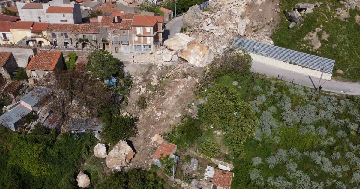
Several damages caused by bad weather, yesterday in San Fratello, a small town in the province of Messina, the tragedy was touched due to a landslide.
The "incalculable damage" according to Coldiretti
Thunderstorms and hailstorms have caused 'incalculable damage' throughout Italy to the crops of fruit, vegetables, sunflowers, barley and wheat up to the olive trees and vineyards of Chianti. This was noted by Coldiretti, which has drawn the map of the effects from Piedmont to Puglia.
"
The fall of hail in the countryside is the most harmful in this seasonal phase for the irreversible losses it causes to crops in the fields on the eve of harvest, sending a whole year of work up in smoke", notes the agricultural organization in a note.